Wednesday 28 September 2011

Marla to Coober Pedy

Wednesday 28th September

It was a nice late start today - wake up at 7, on the road by 8. We continued south, the landscape becoming progressively more arid. We made a refreshment stop at another cattle station roadhouse, which advertises itself as 'the Gateway to the Painted Desert', and I took the opportunity to photograph one of the road trains which we see so frequently on the Stuart Highway.


They can be up to 54 metres long, and are a major feature of the long drives in the Northern Territory. There is very little traffic at all on the long straight road, and I notice that each passing driver is greeted with a wave.

The drive to Coober Pedy takes you through a landscape that becomes progressively more dry. Eventually, you arrive at what at first sight might appear to be spoil heaps, but turns out to be a range of low hills.


Some of the landscape is so bleak and arid it might almost be on the moon.


Another interesting feature is the dog fence, which keeps dingos out of sheep country.


It is 5300 km in total, of which 2250 km are in South Australis.

We reached Coober Pedy in time to make lunch. Paul and I, having paid for upgrades, have another motel room. Our fellow travellers are staying in an underground backpackers' hostel. About 50% of Coober Pedy homes are built underground, or at least into a hillside. This means they are at a constant temperature of 23 - 25 degrees, which is an advantage when summer temperatures can rise to 50 degrees. I suppose it also saves you from having to endure the dust storms (which we are having at the minute) or the swarms of flies which I understand are another feature of summer here.

After lunch, we had an opal mine tour. It was particularly interesting to see the parts of the mine hacked out originally with pick and shovel. These days, machines are used. We also saw an example of an underground home, from the 1970s.


It also had a 1970s kitchen


We went to the opal shop, where I chose my birthday present, a beautiful pair of green opal earrings. But I can't contemplate wearing them until the dust storm dies down!

We had a tour round the town, which really only has one street, the population being only 3500. The town is very dusty - particularly now with the dust storm blowing. Parts of it are full of wrecked cars.


It has been used for filming at least one of the Mad Max movies, and various other movies whose names at present escape me (there's a crashed spaceship from one of them just outside the backpackers' hostel).

Later, we went to try 'noodling' in the spoil heaps for opals, but the sand-blasting from the dust storm was painful and most of us gave up quite soon. On the trip to Alice Springs, one of our fellow travellers had a Lonely Planet guidebook which said that you might be forgiven for considering Coober Pedy 'a post-apocalyptic shithole' and in summer, when it is so hot and full of flies as well, I can understand that description.

This evening, we are going to a Pizza restaurant for supper, and afterwards we are off to kiss a kangaroo. Though I am so desiccated and dusty by now that I imagine any self-respecting kangaroo will absolutely refuse to kiss me!

- Posted using BlogPress from my iPad

Kings Canyon to Marla

Tuesday 27th September

We camped last night in what is called a 'bush camp', which is to say it was miles from civilisation, out in the bush. There is some electricity in this one for hot water, lights in the loos and kitchen, from solar panels. Some bush camps have only candles and you cook on a fire, so this was relative luxury! However, the tents were small and very hot, so we decided this time we would sleep outside in a swag.

A swag is a rolled up canvas bag with a mattress inside it. You unzip the canvas, put your sleeping bag inside, and zip yourself into sleeping bag and canvas swag. In my case, I have a silk inner sleeping bag, so I was inside that too. In fact, it being a hot night, I started out just inside the silk inner bag, with the canvas of the swag just loosely covering me. As the night went on and it got colder, I got inside the sleeping bag and zipped up the swag. It was nice to sleep out under the stars, and somewhat better than the airless little tent. The main problem was the dry little wind, which desiccated me overnight so I was a bit dehydrated when I woke up, and staggered a lot. I am really sad to have no photos, but it was dark both when we unrolled the swags and at 5.30 when we rose and rolled them up again.

There were also not enough loos and showers, and there were queues; some idiot had left the door open and the light on, so the place was full of moths practically the size of bats. I was physically incapable of stripping naked to shower with such monsters in the place, so shut the door and took my flip- flop in my hand and murdered them all.

The purpose of the 5.30 start was so we could breakfast and pack and leave by 6.30 and be at Kings Canyon for 7 to start a 3 and a half hour walk. By 11, the temperature would probably be 36 degrees, and possibly up to 10 degrees above that if you were walking on any bare rock faces. There were two walks on offer, the difficult and steep one around the canyon rim, and a less demanding and shorter one along Kings Creek.

We opted for the shorter walk, and watched some of our fellow passengers starting the stiff climb up to the canyon rim.


It was really quite pleasant walking at 7a.m. in the relative cool along a shady path, and our walk followed what would be the creek bed, were there any water.


The gum trees were very tall, showing that they were very old, and their deep roots were able to access underground water. In fact, there was a great deal of vegetation for such a dry area.


We walked as far as permitted by the park rules. The creek is a sacred area, so you are not meant to go right to the end. However, we had a very good view of the head of the canyon.


We headed back for the shade, where we had about two hours to wait for those of our fellow travellers who had opted for the longer, hotter walk. I got dehydrated again and found it hard to stand. As i was sitting in the shade, i had failed to drink enough -the water tasted nasty.

We drove off to a place where we could make an early lunch, and by just after 12, we were off to start a 6 hour drive to Marla where we are to spend the night. On our way, we stopped at the border between South Australia and the Northern Territory.


After dark, we arrived at Marla, which is a cattle station; it has a roadhouse, a caravan and camping site, and a motel. We have a motel room - no more camping for us!

There is no phone signal of any sort, so no idea when this can be posted -we are in the middle of nowhere.

- Posted using BlogPress from my iPad

Uluru to Kings Canyon

Monday 26th September

Well, I ended up not sleeping in the swag last night because it got so cold and because a rain storm was forecast. I slept in the tent, and was frozen. Apparently, the swags were much warmer. Also, there was no rain. So I would probably have been better in the swag. I may try it tonight.

Another reason for not trying the swag was the shortness of the night - we arose at 4.30 a.m. so as to observe the sunrise over Uluru. This was almost as much of a waste of time as the sunset one. The sun was obscured by clouds, so there was virtually no pink light and certainly no colour effects on the rock itself.


We then spent some time at the Cultural Centre learning the stories of the local Aboriginal people. I also had to buy a hat, as I discovered I had mistakenly left mine behind (it had fallen between the bed and the tent). The new hat is cream coloured, embroidered all over with big black flies, and it says 'Wot flies?'


At 8 a.m. we were back in the bus and off to walk round the base of Uluru. For the first time, we saw views you don't normally see on the postcards and calendars.


We found the walk very interesting, there are so many caves and strange shapes to look at, and I took far too many pictures.


Some of the views are quite stunning.


There were also quite a few birds to see - at one point we saw some martens at a waterhole collecting mud for their nests in one of the caves.

There was another, larger, waterhole


which was near a cave that had been used for thousands of years by local people, so there was a lot of art work to photograph inside the cave. My photographs are rubbish though.

As we walked round back to the beginning we were able to look at the line of people climbing up and down. The slope looked impossibly steep and horrifying. The local people have leased the land back to the government, and have agreed that for 30 years, tourists can continue to climb it. However, they are begged most earnestly to choose not to do so. In spite of this, many people do climb - 3 of our party did so - apparently the views are stunning but the climb is classed as dangerous and apparently 38 people have died, either by falling or by having a heart attack. I nearly had a heart attack just looking at it!


By then it was 10.30 and the sun was burning down. We met two Aboriginal guides and an interpreter and went off for another hour's walk to hear their stories. We saw the different caves - one used by the men for teaching the adolescent boys (it was full of art too - like a teacher's blackboard)


one cave used by the women and children, and one by the old people. We heard some of the local creation stories. In one cave, there is what looks like a giant footprint made of stone.

It was all very fascinating but by 11.30 most of us were too tired to do more than stumble along behind them, and were extremely glad to be able to return to our air-conditioned bus. We said farewell to Uluru


and drove back to the overnight camp to make lunch (and retrieve my hat).

Then it was a 4 hour drive to Kings Canyon. We made a quick stop after an hour to view Mount Cullen, but it had disappeared in the smoke and heat haze.


- Posted using BlogPress from my iPad

Sunday 25 September 2011

Alice Springs to Uluru

Sunday 25th September

We were collected around 6.30 this morning from where we were staying, and set off immediately.

The landscape began by being the 'Desert River' environment we had seen in the Desert Park yesterday. The Todd River is just a wide bed of sand, but there is obviously water below the surface, since there are trees and plenty of other vegetation.

Incidentally, Alice Springs is the venue for the Henley-on-Todd regatta every August, when teams build boats with no bottoms so their feet come through, and hold races on the dry river bed. It has had to be cancelled a couple of times because there was rain and the river bed filled with water.

Gradually, the landscape became arid semi-desert, with scrub and clumps of grasses on the bare red earth. There were huge patches which had been burned, either as part of land management or as a result of wildfires, so the view was always hazy. And for quite a lot of the morning, it was cold!

Our first stop was at Stuart Wells Camel Station where you could ride a camel if you wanted. Having ridden a camel in Egypt, we weren't keen, nor were any of our fellow travellers, but plenty of other people wanted to do it.


I must say these camels looked much easier to ride than the ones in Egypt -these ones had stirrups and handles on the saddle to hold on to!

I wandered off to look at the baby camels, who were quite cute. One was missing its mother and kept trying to suckle from its sibling, who was extremely fed up with the whole exercise. Poor little things! There were also some llamas and some kangaroos; the latter wanted to be outside hopping off somewhere and were nosing miserably at the corner of their enclosure and looking hopefully at me. There was also a dingo who was treated as if he were a dog. He didn't look too thrilled about it though!

We made two other brief stops, one where we turned off the Stuart Highway, and one at Curtin Springs roadhouse. The latter is a fuel and food stop on a 1million acre cattle station also called Curtin Springs, and we did see a few cows. We saw what we thought was Uluru in the distance, but it was a different outcrop, Mount Connor. It was hard to see anything though, because of the smoke haze from the fires.

At about 1.30 we arrived at our camp site, where we made lunch in the camp kitchen. When lunch was over, we were off to Kata Tjuta, another sandstone outcrop with many domes.


It is hard to describe the appearance of these, rising straight and sheer out of the arid semi-desert, and a deep red colour. You can see they are a bit hazy because of the smoke, which makes it difficult to see them from far away, but you can understand why Aboriginal people feel it is a sacred place.

We walked along one of the trails which go between the rock domes - being such a sacred place, you are not allowed to climb them. The trails are rocky and rather difficult, being a sort of volcanic stone stuck together with mudstone. The section up to the first view point is is rocky, but not too difficult, but it becomes harder further on.


The sandstone walls of the rock domes have been polished by the wind and the appearance is quite striking.


After the first viewpoint, I went back to the bus. Paul went on, but said it became much steeper and even rockier, so I was glad I had gone back to the bus.

We went on to another viewpoint to see the sunset over Uluru, but it was rather disappointing because of the smoke haze, which was not improving.


Then it was back to camp to prepare supper. Tonight we are supposed to be sleeping in a swag under the stars. I am going to try it, as long as it doesn't rain. There has been some rain today, so I am hoping there won't be any more. If it rains, I will be in the tent!

- Posted using BlogPress from my iPad

Saturday 24 September 2011

Alice Springs

Saturday 24th September

We had a rather late start, and went off to take a walk round the town and do some minor shopping. There are only about 4 streets of shops, though it took us quite a time to find them - our hotel is not central, so it is a 10 - 15 minute walk into town.

There was an interesting mural on the wall of one of the supermarkets illustrating some of the town's history - it was another town that grew from being a telegraph relay station, and also a rail stop, a stop on the Stuart Highway and an airport. The mural, which is very long and took me 3 separate photos to cover, illustrates all of these, as well as showing some of the pioneers (including women), the cameleers and the Aboriginal people. Only a few of these show on my picture.


There are hardly any old buildings, the oldest is the Town Gaol, built in 1908, but I rather liked the original Hospital, built in 1928, and now housing a Museum called Adelaide House, giving information on John Flynn's vision of the flying Doctor Service.


After shopping, we went to the Visitors' Centre where we booked a bus to take us out to the Desert Park. The bus picks you up from your hotel, so we went back there, stopping only for an ice cream - banana and chocolate in my case, one of the most wonderful ice creams I have ever eaten!

The Desert Park combines various different habitats with aviaries of indigenous birds, many of which the visitor can walk through. The Desert River is a habitat I had not imagined, it can be quite fertile even when the river dries up during the dry season, because there is often water underground.


There were many birds in the associated aviary, including this rather beautiful kingfisher.


He was sitting on a branch with a number of green budgerigars, but it was hard to get them all in the same photo. At least I was able to get a photograph of them through the window. In the walk through aviaries, the birds mostly flew around you far to fast to be photographed.

In the aviary associated with a waterholes, it was possible to photograph a number of birds who seemed to have no fear of humans, including this handsome heron.


We went to see a stunning display of different birds flying to lures. The galahs were very funny, swooping low over the heads of the audience. The magpie did some amazing flying, taking insects thrown up to it, and rarely missing. There was a very handsome owl, who preferred to catch things on the ground.


The kites too caught things in the air. All of these birds are quite free, they do it for the reward.

There were animals too. The kangaroos were lying about under bushes looking rather like thugs, though I managed some more traditional photos too.


There were also emus, and a whole Nocturnal House full of animals I had never even heard of - large and small leaping things all going hippity hoppity in the gloom of their small enclosures, but no photos were possible. There were also reptiles and several large spiders but I didn't look at the latter - I don't like spiders!

When it closed at 6, the bus took us back to the hotel. It has to be early bed again tonight, as it's up at 5.15 tomorrow for the 6.15 pickup to set off towards Uluru.

We're going to be in the wilderness again for a few days, so I'm not sure when I can next post anything. We are sleeping out under the stars in a swag tomorrow!

- Posted using BlogPress from my iPad

Friday 23 September 2011

Banka Banka to Alice Springs

Friday September 23rd

We had a better night than usual recently, because it cooled down very rapidly once the sun was down, and by 2 a.m. we were glad of our sleeping bags. It was not a long night though, we were up at 5.30 and away just after 6.30. We made a brief fuel and refreshment stop in Tennant Creek, then we were on our way to the Devil's Marbles.


These enormous boulders are intrusions of molten magma that never quite made it to the surface. They cooled and fractured underground, then the covering layer of sands was eroded off, exposing them to erosion. They fractured into rectangles, rather like a block of chocolate, and the original rectangles have eroded into these shapes, often oval or round.


The whole place is somewhat like an enormous sculpture park, perhaps by Brancusi, and we wandered about for an hour, photographing the strange shapes.


While we were awaiting the arrival of our bus, which had dropped us off at one car park so we could walk to another, we were visited by some of the local fauna, who wanted to see if we had anything to eat. First was a bower bird who whistled loudly at us and strutted about pointedly in the hope that we would understand what he wanted.


Next was a dingo, but he said nothing, only looked very sad and hungry and then went away. Last were some crested pigeons who poked round our feet cooing softly and posed nicely for the pictures.


Our next short stop was at Wycliffe Well, known as the UFO capital of Australia. Apparently strange lights are often seen by most of the people who live there, so they have set up a a sort shrine to UFO sighting. It looks like a theme park outside, and inside it is full of UFO stories from around the world which have been stuck to the walls.


Our next stop was Barrow Creek Telegraph Station, where there was an original OT station built in the 1870s. It gave you an impression of how isolated life was then in places in the outback. It was a low rectangular stone built house with a verandah, some adjacent sheds and a blacksmiths forge.


Early pictures from around 1900 on display showed no sign of any road of any kind, though now the Stuart Highway passes by a few yards away. Just a few yards further on was Barrow Creek Hotel, a small pub run by an eccentric called Mick who had memorabilia from all round the world stuck on the walls and stored in plastic bags on the bar counter. People give him all sorts of stuff - he has examples of London Oyster cards, for instance. Sadly, most of his English memorabilia is from football teams, so he must have thought we were very strange, not being at all interested in football. He had lots of stuff to show all the different nationalities on our bus.

We ate our sandwiches there, before getting back into the bus. Our next brief stop was at a place (for want of a better word) called Ti Tree, for fuel. This part of Australia seems full of places that aren't really anywhere at all, and I imagine are just to cater for users of the Stuart Highway and the few farms around. Just after that, we stopped very briefly at a mango farm for some delicious mango ice cream. Although this area is just scrubland and looks very dry, there is artesian water and that is used by a lot of local farms to grow fruit and vegetables.

The last stop was made when we crossed the Tropic of Capricorn again, going south this time.


Then it was on to Alice Springs where we said goodbye to most of the people on this part of the trip at a farewell dinner. We have one day in Alice Springs to recover, then we start all over again, with a 7 day trip to Adelaide.

- Posted using BlogPress from my iPad- I finally cracked the photograph problem, so Paul should get the PC all to himself!

Katherine to Banka Banka

Thursday 22nd September

We passed a quiet night, apart from a necessary visit to the toilet block at 4.30 a.m. What was remarkable about this was the large green frogs which live in the lavatory pans! Their bodies are about 3 inches long and they cling on up near the rim and seem to cling on very tightly, so the flush doesn't dislodge them. When I flushed, mine had to change its grip and extended a very long leg with large circular pads on each of its toes. As I don't usually carry a camera when visiting the loo in the middle of the night, I didn't get a chance to take a photo, and in the morning there wasn't time, I barely got my case onto the bus before it left, and my teeth had to remain dirty until later in the day. Apparently, some of the gents' lavatory pans contained two frogs, but nobody seems to have thought to take a photograph. I wondered if it was a new species, but apparently they are green tree frogs.

After driving for about an hour and a half, we passed through Mataranka township, one street with a Police Station, a service station, a cafe, a bar, and a shop. It has a caravan and camping site, because people go there to visit the hot springs. These springs became popular during the war when Mataranka, originally a homestead, became a staging post for the Australian army when it was moving up from Sydney to Darwin. The officers had their own springs, but the men used Bitter Springs, which is the one we visited.

The water is warm - about 34 degrees - and it is crystal clear. But the heat generates algae which line the banks, so you have to keep away from the banks while you swim. The whole area is very lush, with overhanging palms and other trees, and is really very pretty. It isn't a true hot spring, the water is a river which arises from groundwater heated by thermal activity, so there is no sulphur smell, just a dreadful smell of decaying vegetation. However, the water was very refreshing, though we were careful to keep our feet off the mostly very slimy bottom.


We stopped at a set of steps about half way along the swimming area of the river, and the tour guide told us that there was even more weed and algae in the next bit. She also told us we were supposed to have brought our flip-flops so we could walk back along the stony path. We had failed to hear that instruction - or, indeed, that she had given any instructions at all. So we said that we would swim back against the current. This proved impossible, even for Paul, the current being quite strong round a bend in the river. An attempt to walk back along the stony path also failed because the small sharp stones and gravel were just too painful. Fortunately, one of our group came past, and he kindly walked back and fetched our shoes.

Our next stop was at a pub in called the Pink Panther in Larrimah, another place which hardly exists.


This has real coffee (which we have been unable to get anywhere we have been in Australia) and a 'Zoo'. This consists mostly of birds, and mostly birds in cages rather than aviaries. Most of the cages also lack what London Zoo refers to as 'enrichment' so the birds, mostly parrots, parakeets, lorikeets and birds of that type, look quite bored and glad to see people because it gives them something different to look at. The poor old sulphur-crested cockatoo had pulled out all his breast feathers from boredom, and looked a bit like a plucked chicken.

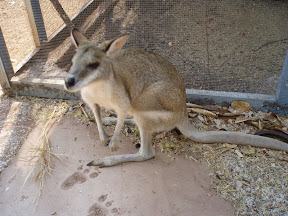
There is a friendly little wallaby hopping about which lets you stroke it,


and the emus are also quite friendly and interested to see you. The saltwater crocodile is called Sneaky Sam because he hides, but I spotted him under his jetty. He won't be able to hide there much longer, the jetty is only about 5 foot long, and so is he. The freshwater crocodiles were so bored they swam over to see if we would do anything interesting (such as give them a fish, perhaps?)

The next stop, for lunch, was at the famous Daly Waters pub. Daly Waters consists of some tin shacks, a service station, and the pub.


The pub is also, apparently, the police station, post office and general store. The bar in the pub is full of signed things stuck to the wall.


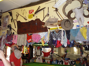
This started when men setting off for a few week's casual work left their existing money with the publican, signing their name on the notes so there would be no doubt about the owner. When the notes had been there a while, the publican pinned them to the wall to remind the owner he had their money. Now people who stay there leave all sorts of things - tee shirts and hats mainly, with a fair number of underpants, bras and pants and so on. The old wooden barroom is crammed with them.

We used their barbecue to make lunch, then had a swim in their pool - or rather, we sat in the lovely cool water for 45 minutes so we could get nice and cold. It is a burning hot day again. Our next stop, only a mile away, was at the original Daly Waters international airport.


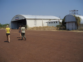
Daly Waters was first a relay station on the overland telegraph, and only had the relay station building. Later, a pub was opened for passing drovers. In the 1920s, Bill Pearce and his wife opened a general store, which did not do too well. In 1931 he won the the contract for re-fuelling the De Havilland Moth for the Department of Civil Aviation. With the advent of international air travel, Daly Waters became a re-fuelling point for planes flying north from Sydney and Adelaide to Darwin and beyond. A new airline called Quantas (Queensland and Northern Territories Airline Service) began using the airport for re-fuelling their mail flights, and later started a service between Brisbane and Singapore. Before long other airlines followed and soon three planes a week were stopping there to re-fuel and for the passengers to be fed. This continued to expand, and during the war, Daly Waters became an important re-fuelling stop for planes flying to defend Australia from the Japanese. After the war, it began to decline in importance and was eventually closed in 1971. According to the Lonely Planet guide, the famous pub is mostly constructed from the original Pearce house.

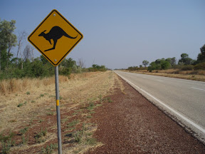
Our last stop, at Dunmarra, was for fuel and to look at the snakes. I held the big python, which seemed to like me - she got on me a second time when somebody else was holding her. Then it was a long drive to our next campsite, broken only by a stop to photograph the first kangaroo warning sign, and the very long straight road.


The landscape is starting to change. It is still savannah woodland, but the trees are fewer and shorter, and are mainly acacia rather than eucalyptus. There are far fewer termite mounds, and the ones that exist are small.

Banka Banka, where we are staying, is nowhere in particular, just a camping and caravan park about an hour north of Tennant Creek. Once again, we have the little huts with canvas walls and roofs, only this time it is a very long walk to the toilet block. The kitchen/diner is a real wooden building this time though.

Wednesday 21 September 2011

Darwin to Katherine

Wednesday 21st September

I seem to have a weak Vodaphone signal, in spite of being in the wilderness, so I may be able to post some text, though not photos.

I think today can be summarised by saying
Sat in the bus
Sat in the Cultural Centre
Sat in the river
Sat in the boat
Sat in the bus.

The alarm went at 4.45 and we were on time, though the bus picking us up wasn't; we could have had an extra half hour in bed!

We drove through more savannah woodland out of Darwin, and then more stone country. At least this bus has air conditioning so we haven't been so unbearably hot while travelling. We made a breakfast stop at a pub at Adelaide River where they have the stuffed water buffalo which starred in a Crocodile Dundee film. Its name is Charlie, and apparently it was stuffed and kept because it was famous.


The pub owners wanted to keep it on the bar, but the bar was so high and Charlie is so tall that his horns got in the way of the fan. Lowering the counter was too expensive and apparently nobody thought of moving the fan. So they cut bits out of Charlie's legs, so he now has stumpy legs. Only in Australia...

Once in stone country, we were nearer to Katherine Gorge, where we arrived about 12 and made lunch. We inadvertently disturbed a bower bird, by lunching too close to its bower, a rather colourless affair,


and it shouted and swore at us all through lunch.

Various walks were on offer, but the heat was really fierce and nobody could face a walk. Some of us went instead to the air conditioned Cultural Centre for coffee and to look at the displays, which explained the history of the park and tied it to the history of the local tribes. There were also slide shows - a nice chance to sit in a cool place.

We had booked a cruise in the gorge, and until it was time for that to begin, Paul and I went down to the swimming place to swim. The swimming place was surrounded by crocodile warnings, but salt water crocodiles are unlikely in the dry season, and lots of other people were swimming, so we went in. The water was very cloudy because of all the sand being stirred up by the boats, so I contented myself by sitting in the water up to my neck until I had cooled off. Then we put our clothes on again on top of wet swim suits and went off to the boat cruise.

Katherine Gorge is really beautiful, with high red cliffs of fractured sandstone.


There are several gorges, and we took a boat down the first one; then you have to get out of the boat and walk 400 or 500 metres to the second gorge.


This is Katherine Gorge itself, where you get on another boat and go all the way down that - somewhere between 2 and 3 kms.

It is so picturesque with the high cliffs and green trees growing out of many places it is hard not to keep clicking the camera. Everybody, including me, took lots of pictures and, in my case, they were mostly full of hats. It was bakingly hot again, and everybody was wearing huge hats and lots of sunscreen and drinking lots of water.


Incidentally, Paul and I have both had a lot of trouble with agonising muscle cramps in the legs, and initially were told this might be dehydration. But apparently it is just as likely to be because we are losing body salts by sweating so much. So we have been taking isotonic drinks and hoping to spend a better night. But my feet and legs are swollen enormously and are most uncomfortable. And it's home sweet tent again tonight, and tomorrow night. The night after that, we are in a motel in Alice Springs.


We saw some rather sweet wallabies near the Katherine Gorge car park ,just after 5, especially a mother and a joey, and were able to get some pictures. They didn't seem too intimidated by people.