Wednesday 30 November 2011

Methven to Hanmer Springs

Wednesday 30th November
Well, we finally managed to get flights sorted out. We fly to Auckland on the evening of December 3rd which was not quite what we intended. We had hoped to fly out on the afternoon of December 2nd and had booked the hire car accordingly. Paul spent some time calling the car hire people, as we now need to keep the car for another day. Unfortunately, we can only have it until 10 am on 3rd, so we have most of a day in and around Christchurch with no car! We will book in somewhere in Christchurch for the night of December 2nd and hope we can store baggage there the following morning after checkout until the afternoon.

After we had sorted that, we went to the Methven Visitors' Centre for a guide to Mount Hutt walks. There are quite a few walks, but nothing much near the ski area. It turns out that the one unmade (and currently closed) road to the ski area is, in fact, a private road! I find this quite odd for one of New Zealand's premier ski areas. They obviously do things differently here!

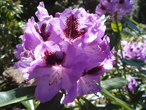
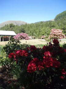
We drove up to the Mount Hutt walking area, and it begins in a park which has been planted with Rhododendrons. We have been admiring the Rhododendrons and Azaleas in New Zealand for some time, but it is almost the end of the season now, so most of these were on their last legs. There was still a fine show though, in every imaginable colour from white through pale pink and peach to orange, crimson, lilac, burgundy and purple. Some are two-toned, with a deeper colour at the centre.


The parkland in which they are set leads right into the forest which clothes the lower slopes of the mountain.


After admiring the flowers, we took a couple of the trails up the mountain through the forest. One forest walk being much like another, I won't put any more pictures. It was pleasant in the quiet of the forest with no sounds but birdsong but after about an hour and a half of walking and climbing through the forest with nothing much in the way of views, I was pretty tired. We could have pressed on above the tree-line but but it might have taken most of the day, so we climbed back down the hill and went back to the car to eat our sandwiches, it being lunch time by then.

We continued on the scenic drive, taking the road to Rakaia Gorge. It is hard at first to imagine where the gorge might be, since the land seems so flat. But this is deceptive, it is a plateau I think, because suddenly the road drops steeply and you reach the gorge.


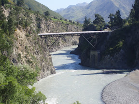
It is quite hard to find a place to take photographs, since stopping places are few and far between. There are two bridges, a more modern concrete one built in 1945 which you can see before you cross the river. It replaced an old wooden one. You can see it on the right of this picture.


The second bridge is a much older one, built in 1882, which spans the deeper channel of the river, the river channel you may be able to see to the left of the concrete bridge in the picture above. You have to cross the river first, then find a place to stop and walk along a little path to get a view of this bridge.


I must admit, I have never seen anything like this old bridge, it is highly individual.

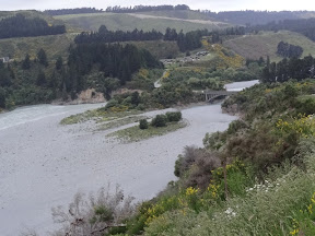
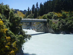
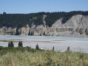
We continued on along the road, which is somewhat inland and, though it passes along the edge of the Canterbury Plain, skirts the hills and is a far more interesting drive than the coast road. We passed another gorge, that of the Waimakiriri River, and stopped again to take photos. On one side of the bridge, the river has cut deeply through the rock, leaving high rocky cliffs. This was obviously a good spot for a bridge.


Below the the bridge, the banks are obviously much softer and more sandy, and the river bed becomes wider, braiding its way across gravel beds.


We found an unsealed road along a hillside on one bank of the river, and drove up to get an overall view.


You can just see the bridge from which I took the first picture, standing on its rocky outcrop.

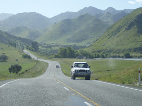
We continued on, joining State Highway 1 for a short while just north of Christchurch, then swinging back inland for another scenic drive. The countryside was hilly with pastureland at first, but gradually became higher, with many rocky outcrops.


Although not mountainous, the scenery was spectacular, the hills mostly bare and steep sided, often coming to a sharp point. The road is generally straight and most of the time sticks to the river valley, so the speeds are fast and there are a fair number of vehicles.


It is almost impossible to stop for pictures or even to drive slowly, as there is usually at least one car attempting to get into your back seat, so I have been reduced to photographs taken through the front windscreen. Any blobs on the picture are probably dead flies on the windscreen - or worse.

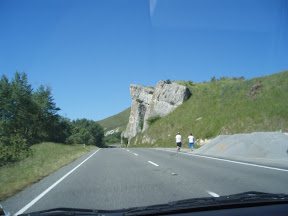
The road we were on goes over a pass and on to the west coast. But we had no intention of going to the west coast, and no time. We turned off on a smaller road which goes to Hanmer Springs - I'm determined to get to some hot springs somehow or other! Shortly after we turned off, there was yet another gorge - it must be our day for gorges! This is the bridge over the Waiau River, probably our most spectacular bridge of the day!


It wasn't far from there to Hanmer Springs, which is a delightful little town (my guide book calls it an 'alpine village') with hot springs first discovered in 1859. We are staying here for two nights to relax a bit and so I have time to visit the hot springs. Tomorrow's posting might be a bit short though - there isn't a lot you can say about lying in hot water for hours, and that's what I intend to do!

- Posted using BlogPress from my iPad


Tuesday 29 November 2011

Omarama to Methven

Tuesday 29th November
We didn't make an early start this morning, in spite of the fact that the weather was absolutely beautiful. We slept until 8, then fiddled around with computers. Then Paul started to worry that we still hadn't heard from the travel agent who we asked to change our flights to Auckland. We want to spend a week in North Island, instead of being in South Island until December 10th, and, according to the Quantas/Jetstar website, you can't make the change yourself, your travel agent has to do it. But our travel agent hasn't replied. Paul decided to email again and wrote a long email, then lost his Internet connection and also lost the email. Eventually, we packed and checked out, then sat on the motel patio and used my iPad to re-write and send the email. But we didn't leave until almost 10.30.

We started to travel towards Lake Tekapo, a journey we have already made in the tour bus. I had to beat Paul with a stick because he kept insisting on stopping to photograph irrigation systems; I have no idea why he finds these fascinating. It's not as if we haven't seen irrigation systems before. I have made him promise not to bore friends and family with such photographs.

As well as the irrigation systems, we continued to admire the Russell Lupins all along the verges of the road, particularly nearer to Omarama. There must be something about the soil or the climate that they like. I photographed these while we were stuck at some road works.


The sky was a clear blue, the sun was shining and there were hardly any clouds. We stopped at Lake Ruataniwha when we saw these wonderful reflections in the beautiful blue lake.


We had to turn and come back to find a place to take this photo, and had not long been on our way again when we noticed a huge white apparition on the skyline.


Mount Cook had pierced the clouds enough to appear to us for the first time. You can probably see the skirt of cloud beneath the peak, so we hurried to get closer before the clouds hid everything again.

At Lake Pukaki, we noticed that the lake and the mountain made a beautiful picture, and that the clouds were threatening to cover everything, so we turned back once again and went back to the Visitors' Centre to take more pictures. This is the closest we could get.


Shortly after this, the clouds covered most of the peak.

We spent a bit of time in the Visitors' Centre looking at the information boards. I was particularly interested in one about James Mackenzie, for whom Mackenzie County and the Mackenzie Pass were named, since he discovered a pass and plains unknown to local settlers, though known to the local Maori. There seems to have been some uncertainty about whether he was a shepherd or a thief; he was imprisoned for theft, but many felt his trial was unfair, and he received a pardon.

We set off for Lake Tekapo, where we lunched. The lake was every bit as beautiful as it was before - still the intense blue colour.


The wind was becoming rather cold, and I began to regret putting on cut-off trousers. We pressed on for Geraldine, this time not viewing giant sweaters or mosaics with 2 million pieces. We did have a cup of coffee though, and I put on warmer clothes.

We wanted to avoid the rather boring road across the Canterbury Plain, so we took the scenic route, which skirts the edge of the hills and goes close to the ski area. The landscape was slightly more interesting than the trip across the plain. It is very rural and looks quite English, with green pastures and rolling hills. Eventually we reached Methven, which is the après-ski area for the Mount Hutt ski field, and where we decided to stay.

To our surprise, it seems completely flat around Methven. It is about a half hour drive to the ski field, and there is no accommodation up there, so everybody makes the journey up from the town and then down again every day. When we decided to go and look at the ski area for ourselves, we discovered that the road up the mountain was not made up, just gravel, and that it seemed to be closed anyway. This seems very odd to us, being used to Alpine or American resorts, with accommodation on the slopes and good roads with lots of transport. There are supposed to be some walks in the area, so we may take another look tomorrow if the weather is fine.
On the way to the ski area, we passed this field.


We really aren't sure whether or not these are wild Lupins, as the field is so huge. It really does show most of the colours we see all the time, though there are more of the paler ones here than we have seen on most roadsides. We have sometimes seen big groups of wild flowers like this in the distance, usually in river beds, but never any so close to the road.

- Posted using BlogPress from my iPad

Monday 28 November 2011

Invercargill to Omarama

Monday 28th November
We woke to find it was raining heavily in Invercargill. It's just as well Paul took some photographs in Invercargill last night, or we would have none at all.

Invercargill isn't very big, but it does have one or two interesting buildings. This is the old Railway Hotel, dated 1896.


and the Town Hall and Theatre (seems an odd combination to me) completed in 1906.


Consultation of weather forecasts indicated that it would also be raining in Dunedin, so we opted to head towards Queenstown, where a fine afternoon was expected. The rain on the way there was very heavy, just like the Milford Sound rain, but fortunately it had mostly gone off by the time we arrived in Kingston, in time to see the Kingston Flyer. This wonderful old heritage railway has recently re-opened after being sold. The two locomotives date from the 1920s, and the old wooden carriages from 1898.


It wasn't due to leave for 2 hours, and the 24 km journey (12 km to Fairlight and 12 back) takes 90 minutes; so Paul decided not to wait, and we pressed on. The journey along Lake Wakatipu was very disappointing, the lake and hills being all but invisible in the mist and rain. We ate our sandwiches in the car! We went to a charming picnic spot, but was too wet to get out of the car; the rain had started again with a vengeance!

We gave Queenstown a miss and went on to Arrowtown, which we had been disappointed not to see properly when we went through it on the tour. Arrowtown was a town of the gold rush, but it did not become a ghost town like so many others, and many of the original buildings still exist. Fortunately, by the time we arrived, the rain had mostly stopped, and we were able to see the historic buildings. There are many charming cottages, dating from the 1860s and 1870s. We had coffee and sticky buns in this one, which used to be a family home. We sat on the verandah you can see here, decorated with bunting, and it was suddenly quite warm.


There were so many pretty cottages in this street, it is hard to pick just one, but this is very typical.


The main street is also full of historic buildings, but is impossible to photograph them without getting cars in the picture. You can probably see this old Pharmacy below is dated 1862. Many of the shops date between 1860 and 1915 or so.


We went down the hill to look at the Chinese Settlement, where the cottages of the 1860s and 70s were not nearly so charming.


The Chinese gold miners were not welcomed into the community. Many went home when the gold ran out, or to other diggings. Some stayed in Arrowtown for a while, growing and selling vegetables in gardens round tiny cottages like these.

We decided to make next for Wanaka, where I thought we might spend the night. However, we decided to take the scenic alpine route through the Cardrona ski area. We were not too surprised that our tour bus did not take this route, it was absolutely full of terrifying hairpin bends, where the maximum recommended speed was 15 km. The view from the scenic viewpoint was spectacular.


The road was narrow and very twisty, and there were quite a few bays where you could pull in to put on your snow chains. Neither of us fancied the drive with snow and ice on the road. We drove on through Cardrona, but couldn't really see where people went to ski, and I only noticed one ski lift. Eventually, the road dropped down towards Lake Wanaka, and we were able to take pictures of the lake from the hills above, which we hadn't been able to do from the tour bus. There is still snow on the high mountain tops.


At that point, it had been my intention to stop, as it was almost 5, but Paul decided he would like to go on, so we drove towards Omarama, where we had stayed before. I see from our tour itinerary that we didn't drive this route before either. The sides of the road were ablaze with Russell Lupins, pink, lilac and purple.


We crossed the Lindis Pass, climbing through rocky gorges


and reaching tussock covered hills.


The tussocks are bleached to beige, and the hills are an amazing khaki colour.

When we descended to the plain and saw the approaching cliffs, I knew Omarama was near.


At this point, Paul agreed we should stop and we found a motel, and were recommended to a cafe near the airfield, where, over dinner, we met a Swiss glider pilot. He comes to Australia and New Zealand when it is too cold for gliding in Switzerland.

Posted using BlogPress from my iPad

Sunday 27 November 2011

Dunedin to Invercargill

Sunday 27th November
Although we felt there were still things to see in Dunedin, we decided to set off for Invercargill and see if we had more time for Dunedin on the way back. The only slight problem in leaving Dunedin was the inability to find a petrol station on the way out - we ended up driving towards the airport to find one, just in case there wasn't one in the next town.

The first part of our journey repeated what we had already done on the tour, as far as Balclutha. But it did give us time to stop and photograph the bridge at Balclutha.


Shortly after that, we were off onto the scenic route to the Catlins. We reached the sea at Kaka Point, where some brave souls were surfing.


We thought about taking a side road to Nugget Point, but the road was very poor, so we continued on inland. The road continued round rolling and folded hills; this is mostly sheep country, though a few cattle can be seen from time to time.


Our first walk took us through beech and podocarp forest


to the Purakaunui Falls; the river drops 65 feet over a series of terraces - these are the lower ones.


Another drive took us to another walk and the Horseshoe Falls and the Matai Falls. At the Horseshoe Falls, the river is split into several streams by very hard rocks.


You don't notice at first that there is another stream of water which is descending the wall of rock behind you, crossing the lookout point, and soaking your feet.

The Matai Falls are rather better known, and have more water going over them.


We continued through the hills, and then back to the coast again at Papatowai. Here, you can see the boiling surf breaking on the bar just outside the lagoon.


The road climbs again, providing superb views over the whole area from Florence Hill Lookout.


The road turns slightly inland again, and soon provided another forest walk, this time to Lake Wilkie. The lake is small, and formed after the last ice age, when water was trapped between ancient sand dunes and a cliff.


It used to be much larger and is slowly filling in.

The road winds further inland, and an unmade track takes you to another forest walk and the McLean Falls. I am afraid I was all waterfalled out by then, so I won't post any more waterfall photographs, though I did take some. I don't want any few remaining readers to suffer death from waterfall boredom.

We decided to make directly for Invercargill and miss Curio Bay, as the interesting fossil trees that can be seen on the beach would have been covered by the rising tide. The road continued through some stunning countryside


I took this through the windscreen, which explains the odd spots at the sides. Eventually, the road descended again to the coast and became very flat, and we were in the outskirts of Invercargill.

We found somewhere to stay for the night, but Invercargill is very quiet. Perhaps this is because it is Sunday night.

- Posted using BlogPress from my iPad

Saturday 26 November 2011

Oamaru to Dunedin

Saturday 26th November
We decided to have a further small exploration of Oamaru this morning before setting off for Dunedin, so after we had breakfasted and checked out, we had a look round some less familiar parts of the town.

This incredibly beautiful building calls itself the Community House, as you may be able to see.


There is even an Opera House!


We drove up to the top of the hill for a view over the town and out to sea. It was a beautiful sunny morning, and the sea was the most astonishing greeny-blue.


We set off for Dunedin, and it soon became obvious that, though it wasn't nearly so windy in Oamaru as it had been the previous night, the wind was still blowing very hard further down the coast. We passed several places where trees in the pastures had been blown over, and we were nearly blown over ourselves when we got out of the car. We made a stop at the Moeraki Boulders, just to see if we would be able to see if they would be visible this time. As it was low tide on this occasion, we braved the cold wind and there they were!


Most of these ones had been completely covered by the sea last time we came, so we really have managed to see them this time, not just looked at the postcards!

We arrived in Dunedin around lunch time, and were able to book ourselves onto the afternoon rail trip along the Taieri Gorge. There was just time to have a quick lunch and find ourselves somewhere to stay, before joining the train at 2.30.

The Taieri Gorge railway was originally part of the Central Otago railway. It was started in 1879, at a time when transport in the area was very difficult. The first part opened in 1889, but progress was slow. However, in spite of the very slow progress, the railway played a major part in the development of Central Otago, transporting livestock, fruit and other farm produce down to Dunedin and beyond, and things like petrol, oil, supplies for farms, mail and newspapers back to Central Otago. However, when roads improved, the importance of the line declined. Passenger services stopped in 1979, though freight continued, and the line also began to be used for public excursions and was popular with tourists. The Minister of Railways eventually announced the closure in 1990, and the Mayor of Dunedin immediately said the city would buy the 60 km through Taieri Gorge if the community could raise $1,000,000. Within a few months of the closure, the money was raised and the line opened again as a tourist attraction.

The line passes through Dunedin's suburbs and then green pastures, and then climbs into the hills.


Soon, it begins to follow the course of the river.


There are bridges and viaducts to cross - not to mention 10 tunnels.


The train makes a stop at Hindon, which used to be a busy stop and is now only a hut. The river gorge deepens and becomes much more rocky, and the river is faster flowing.


Eventually, the end of the line is reached at another hut called Pukerangi, and the engine is moved round to the other end of the train to take it back to Dunedin.

My camera battery died, so I began taking pictures on my phone, and I think the phone is better able to reproduce the astonishing vibrant yellow of the gorse.


The train made a different stop for photographs on the way back, at a hill with rather an old-fashioned name - nobody would think of naming a hill like this nowadays.


The views were very good though.


We arrived back in Dunedin, a little late, at 6.45 and went back to our hotel and then out to eat. We found one of those 'all you can eat' buffets, so now we are rather full! We will probably continue our journey south tomorrow.

- Posted using BlogPress from my iPad